A Real Property Report (RPR) is a legal snapshot of your property on the date it’s signed by a licensed Alberta Land Surveyor. It maps permanent, visible improvements against your legal boundaries and highlights features that may matter to buyers, lenders, lawyers, and municipalities.
Below, we outline what an RPR shows, what it does not, and why it matters for everyday property decisions.
So, What Does An RPR Show?
Before we get into the details, remember an RPR is about clarity: it depicts what sits where relative to your lot lines and recorded interests. That clarity helps the City assess placement against bylaws and helps parties to a transaction understand rights and limitations.
Boundaries Of The Property
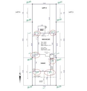
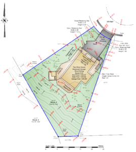
An RPR outlines the surveyed legal boundaries of the parcel, typically shown as solid lines with bearings and dimensions. This frame of reference allows you to interpret setbacks, confirm lot shape and size, and evaluate proximity of improvements to the lines.
Structures On The Property
Permanent, visible improvements — such as the house, garage, decks, fences, sheds, and sometimes retaining walls and AC pads — are plotted relative to boundaries.
Seeing structures in context is what makes an RPR useful: it shows how everything fits together on the lot.
Easements And Rights‑Of‑Way
Utility, drainage, and access corridors are commonly shown as dashed or labeled strips. These areas come with restrictions — permanent structures generally are not permitted inside many easements, and even fences may be limited depending on the terms.
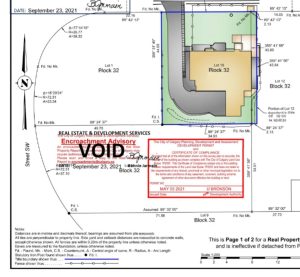
Encroachments
If a feature crosses a boundary or sits within a restricted corridor, the RPR identifies an encroachment. This visibility allows stakeholders to evaluate options such as an Encroachment Agreement or relocating the feature, depending on municipal direction.
Municipal Compliance
Municipalities review RPRs to check placement against bylaws. Outcomes typically include a compliance stamp, a compliance stamp with an encroachment advisory, or direction to pursue a Development Permit for the purposes of attaining a relaxation of the bylaw. Compliance is about ensuring the buildings represent what exists on the latest Development Permit on file at the Municipality. Compliance is not associated with construction quality or safety.
For a plain‑language walkthrough, see: How To Read an RPR
What About What’s NOT Shown On An RPR?
An RPR is designed to illustrate legal boundaries and visible, permanent improvements. It is not an exhaustive inventory of site conditions or subsurface elements.
Use this section to set expectations before relying on your RPR.
Temporary Structures
Short‑term, movable items — like seasonal furniture, portable play equipment, or temporary sheds — are not the focus. The report emphasizes fixed improvements that affect boundaries, access, or bylaw placement reviews.
Underground Features
Subsurface utilities and foundations are not depicted by default. Easements and rights‑of‑way indicate where underground infrastructure may exist, but the RPR illustrates surface conditions observed at the time of survey.
Why Property Value Is Not On An RPR
An RPR certifies where improvements sit relative to legal boundaries and interests; it is not an appraisal. Market value is outside the scope of an RPR and is not stated or implied by the document.
Why Is An RPR Important For Property Owners?
An RPR reduces uncertainty by making the legal and physical picture of your lot clear. That clarity supports better decisions in listing, negotiating, and permitting — so issues surface early, not on the eve of closing.
Buying/Selling
Most Alberta home transactions expect a current RPR with municipal compliance, so buyers and lenders can see what exists and how it’s situated. This transparency builds trust, reduces last‑minute renegotiations, and helps remove conditions efficiently.
Boundary Disputes
By showing boundaries, distances, and any encroachments, an RPR provides a common reference to prevent or resolve disagreements with neighbours. Distances to property lines and labels on features make conversations factual rather than speculative.
Development Planning
When you apply for permits, the City uses the RPR to evaluate placement relative to setbacks, easements, and other rules. Depending on findings, you might receive a compliance stamp, an encroachment advisory, or be directed to seek a Development Permit.
Trust Third Rock Geomatics For Your RPR Needs
Don’t be left guessing about boundaries, setbacks, or next steps for your property transaction or development project. Third Rock prepares clear, easy‑to‑read RPRs and, when requested, manages municipal submission so you get definitive answers — fast.
If you’d like a simple visual primer on interpreting your plan, see our resource: How To Read an RPR